|
|
|||||||||||||||||||||
|
 |
||
|
|
||
|
History of Carterton Carterton was originally known as Three Mile Bush and was founded in 1857 to provide a base for men working on the road between Greytown and Masterton. |
||
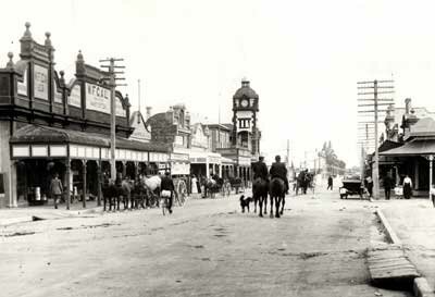 High St Carterton looking South 1910 |
||
| When settlers sought to name their township they submitted to the Provincial Council an assortment of choices, namely Victoria, Alma, Unity, Hope, Clifton and Roxburgh. However, none of these names were taken up and it was not until 1859 that a further petition was presented to the Provincial Council seeking to re-name Three Mile Bush, ‘Cartervale’ and the village in the Three Mile Bush ‘Carterville’. On 26th of July 1859, the Provincial Council in Wellington declared that “the Three Mile Bush and adjacent lands on the east side of the main road, consist hence forth as a township to be known as Carterton”. Settlers had chosen the name in recognition of Charles Rooking Carter who was a strong advocate for Wairarapa settlers and was a member of the small Farm Association on the Provincial Council and General Assembly. |
||
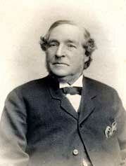 Charles Rooking Carter |
||
During his association was Carterton, Carter built the Black Bridge over the Waiohine River, was instrumental in opening the first public school and was a major benefactor of the Carterton Public Library. He bequeathed 2500 pounds for the establishment of a home, where free board and lodgings were available for the poor elderly men of the district who had come to the end of their working lives and would otherwise be forced to take to the road as ‘swaggers’. Carter donated the land on which Carter’s Reserve is situated and donated 2240 pounds to start a fund for the erection of an astronomical observatory. Carter died on July 22, 1896 in Wellington. His body was brought back to Carterton and he is buried at the Clareville Cemetery. |
||
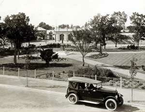 The Memorial Square 1925 |
||
|
|
||
|
Carterton District Profile The Carterton district is located in the Wairarapa between Greytown and Masterton and has an area of 1,145 square kilometres. Originally known as Three Mile Bush, Carterton was established in 1857 to house workers building the road between Greytown and Masterton. Carterton district is bounded by the Waiohine River to the south and the Waingawa River to the north and stretches from the Tararua Ranges to the west and to the Pacific Ocean to the east. Carterton is divided into two wards being urban and rural. The 2001 census recorded a total population of 6878, with 4014 people residing in the Carterton urban area and 2859 people residing in the rural area. Further statistical information of Carterton district can be obtained from www.stats.govt.nz. Mt Holdsworth situated in the Carterton district is the main entry point into the Tararua Forest Park. The Waiohine Gorge also situated in Carterton gives access to the Tararuas and has the longest swing bridge of its type in New Zealand. Gladstone and East Taratahi are rural communities to the east and northeast of Carterton urban area where grape and olive growing is thriving. Further east from the Maungaraki Ranges to the coast forestry is becoming increasingly predominant. The rural land on the western side of the urban area is predominantly used for traditional pastoral farming. Situated at Waingawa north of Carterton township adjacent to the boundary of the Waingawa River is industrial land which is the location of two significant wood processing mills and several smaller operations associated with wood processing, a transport business and road construction firm. State Highway II passes through the centre of the urban commercial area and is the main route to link Carterton with its neighbours to the south and north. Carterton district's roading network comprises 269.7 kms of sealed roads and 167.6 kms of unsealed roads excluding the State Highway. The nearest large metropolitan areas are Wellington and Palmerston North both approximately a 1.5 hours drive from Carterton. Tranz Rail provides a rail service from the Wairarapa to Wellington for the increasing number of commuters residing in the Wairarapa. |
||
| back to top | ||
|
||